Saturday, April 18, 2009

Himalayas


The Himalaya Mountains are the highest, most arduous mountain range in the world. Boasting each and every one of the fourteen highest peaks on the globe, none is more famous, or synonymous with the struggle of man versus nature, as Mount Everest. A map of the Himalayas shows that the mountains actually stretch across six separate countries, and include ranges within the Himalayas, one of which is the Karakoram Range where K2 is found. Mount Everest and K2 are two of the most famous of the Himalaya Mountains, the latter of which is considered by most mountaineers to be an even harder climb. Though a map of the Himalayas shows few peaks actually upon Chinese land, the cloud soaked peaks in Xinjang are only a couple thousand feet shorter than Everest itself, though considerably less notable.
For those who can handle a short ascent, there are thousands of serene lakes that can be found in the Himalayas, the largest being Pangong, on the Nepal-China border. However, few passes throughout the Himalaya Mountains allow people to cross. The least arduous (which is only true in relative terms) are the old offshoots of Silk Road, the Jelep La and Nathu La passes. Even these have charming monikers such as “the Gate to Hell,” named by Nepalese traders due to the impossibility of the terrain.
Though most travellers to China have little interest in climbing these giant peaks, the occasional trip is sent high into these mountains. But Himalaya trekking is hardly advisable for most. Even the smallest peak is often too much for an experienced climber, and any trip should be set up well ahead of time – you will need guides, not to mention all sorts of equipment that may not be readily available in the foothills of China. Most base camps are located along the Tibetan border, the main one being called, well, the Everest Base Camp. Located on the road between Lhasa and Kodari, the camp, and nearby guest houses, are set more for those who want a close up look at the towering mountains. Unfortunately, though, for most the Himalayas are for viewing purposes only. Drowned in snow at their summits, the mountains are unlike any other in the world, and true nature lovers habitually make their way to the foot of the great peaks, basking in the crisp air and majestic scenery that the land displays.

Read more...

Mohenjo-Daro and Harappa


Archaeologists discovered two 4000-year-old cities, 400 miles apart, along the banks of the Indus River in Pakistan. These expertly constructed cities were parts of an advanced civilization comparable to ancient Mesopotamia and Egypt. We don’t know what the ancient people of the Indus River Valley called themselves. Archaeologists named the cities Mohenjo-Daro, which means “hill of the dead,” and Harappa, after a nearby city.
The people of Mohenjo-Daro and Harappa lived in sturdy brick houses that had as many as three floors. The houses had bathrooms that were connected to sewers. Their elaborate drainage system was centuries ahead of their time. Archaeologists have found the remains of fine jewelry, including stones from far away places. This shows that the people of the Indus Valley civilization valued art and traded with other cultures.
We don’t know what happened to the Indus River Valley civilization. It seems to have been abandoned about 1700BC. It is possible that a great flood weakened the civilization. The moving tectonic plates that created the Himalayas may have caused a devastating earthquake. It is also possible that the people may have been defeated by another culture.
What we know about the Indus civilization is evolving. Archaeologists are continuing to find new artifacts. In time, we may learn how this amazing civilization developed, how they learned to create an advanced ancient civilization, and why they suddenly disappeared.

Read more...

Will the world end in 2012?

According to the culture of ancient Maya, part of what scholars call Mesoamerica, astronomy predicts some major cosmic developments for December 21, 2012, including, perhaps, the end of the world as we now know it, as some people believe. Mayan calendars are still used by a few cultures in Mexico, Guatemala, Belize, Honduras, and El Salvador and are said to be the most accurate ones in existence. They date the solar year accurately within minutes, taking account of the cycles of sun, moon, Venus, and other cosmic bodies and only have to add one "leap day" after 380,000 years. Mayan civilisation was quite advanced, possessing technology that modern man is still trying to comprehend.

2012: The Year The Internet Ends:
Every significant Internet provider around the globe is currently in talks with access and content providers to transform the internet into a television-like medium: no more freedom, you pay for a small commercial package of sites you can visit and you'll have to pay for seperate subscriptions for every site that's not in the package.

Photon Energy to Peak in 2012

She says that people are finding there aren't enough hours in the day because of something called the "Photon Energy" which peaks in 2012. "No, it's not the end of the world, but it's going to feel like it to many." Who is she? Her name is Margaret McElroy, or Margaret M as she is known. An Australian now living in Seattle with her husband Alan, Margaret says "The Photon Energy is causing so many problems for people all around the world. We think there are 24 hours in the day, but really there are only about 6 - 8.

An orderly visit of Extraterrestrial Federation in 2012 representing 88 star constellations:

The world is getting ready for something spectacular in 2012. According to researchers, the Federation of the Universe representing all the 88 star constellations will officially visit earth in 2012 and reveal themselves. It will bring an end to all UFO cover-ups in various countries.

Read more...

Saturday, April 11, 2009

Chola Temples


Chola Temples:
The Brihadisvara temple at Thanjavur was built by the potent ruler of the Chola dynasty, King Rajaraja chola in the 10th century AD. This temple is a mirror to the exquisite Dravidian architecture and the paintings, letters and the inscription on the temple walls speak of the rich cultural heritage and high literary progress under this dynamic ruler.
The Brihadisvara temple at Gangaikondacholisvaram was built by another erstwhile leader King Rajendhra Chola, son of Rajaraja Chola between 1020 and 1029 AD. The king after conquering Madurai and Ellum extended his territory till here and carried water from the river Ganges to purify the local water body thus giving this place the name Gangaikondacholisvaram. He later went on establish his capital in this place and also built a temple resembling the structure of the Brihadisvara temple at Thanjavur. This temple though a little smaller when compared to the temple at Thanjavur reflects the Chalukya architecture and also portrays the Pallava and Chola dynasties. The temple was damaged during the wars and was also used as garrison by the Pandya rulers and later on by the British.
Airavateswara temple at Darasuram was built by King Rajaraja chola II and is a true representation of the chola dynasty.

Read more...

Prehistoric Rock Shelters of Bhimbetka


One of the oldest structure standing in maha- balipuram (now Mamallapuram, I still like the old name). There are supposed to be seven temples and all of them submerged. The rest six are still under water. During Indira Gandhi’s visit, she promised to offer national monument status, she did. Now this is the only temple standing on the beach. All the precautions are taken, that the ocean king does not invade this. Still the salty sea doing its work, its ruining the beauty of the wall without even touching it. Once in year chemical treatment is done to remove all the salt from the walls.


The temple was badly hit by Tsunami, and also by British Queen (locals tell she has taken the golden ‘Shiva Linga’ hundred years back ). you can also see remaining of a port 1300 year old. These kinds of docks south east coast only used to make trade with Srilanka and south East Asian countries.


Place: once submerged now protected temple. Gods are Shiva (linga) and ananthashayana. And don’t miss the scripture in ‘pali’ ‘language carved in pedestals. ‘Pali’ was the official language of ‘Pallavas’.

Read more...

The Rock Shelters of Bhimbetka


The Rock Shelters of Bhimbetka (or Bhim Baithaka) lie 45 km south of Bhopal at the southern edge of the Vindhyachal hills. South of these rock shelters are successive ranges of the Satpura hills. The entire area is covered by thick vegetation, has abundant natural resources in its perennial water supplies, natural shelters, rich forest flora and fauna, and bears a significant resemblance to similar rock art sites such as Kakadu National Park in Australia, the cave paintings of the Bushmen in Kalahari Desert, and the Upper Paleolithic Lascaux cave paintings in France.The Bhimbetka rock shelters compose an archaeological site and World Heritage Site. The shelters exhibit the earliest traces of human life in India; its Stone Age rock paintings are approximately 9,000 years old, making them among the world's oldest.
The name Bhimbetika comes from the mythological association of the place with Bhima, one of the Pandavas (The five sons of king Pandu and the queens Kunti and Madri) in the Hindu epic Mahabharata.Bhimbetka was first mentioned in Indian archeological records in 1888 as a Buddhist site, based on information gathered from local adivasis. Later, as V. S. Wakankar was traveling by train to Bhopal he saw some rock formations similar to those he had seen in Spain and France. He visited the area along with a team of archaeologists and discovered several prehistoric rock shelters in 1957.

Read more...

Churches and Convents of Goa

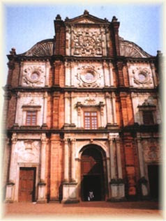
Velha Goa (Goa) is famous for the most spectacular group of churches and cathedrals built during the sixteenth and seventeenth centuries AD. These include Se Cathedral, Church and Convent of St. Francis of Assisi, Chapel of St. Catherine, Basilica of Bom Jesus, Church of the Lady of Rosary and Church of St. Augustine. The Church of St. Cajetan is modelled on the original design of St. Peter's Church in Rome. The Church of Bom Jesus with its facade is decorated with Ionic, Doric and Corinthian pilasters.
The paintings in the churches were done on wooden borders and fixed between panels having floral designs as in the chapels housing the tomb of St. Xavier, the arches above the altars in the transept of the Se' Cathedral and in the nave on either side of the main altar in the Church of St. Francis of Assisi. There are delicately carved painted wooden statues besides a few in stone to adorn the altars, depicting mostly the saints, Mother Mary and Jesus on the cross.

Read more...

Sunday, April 5, 2009

Meenakshi temple


Madurai or "the city of nectar" is the oldest and second largest city of Tamil Nadu. This city is located on Vaigai River and was the capital of Pandyan rulers. The Pandyan king, Kulasekhara had built a gorgeous temple around which he created a lotus shaped city. It has been a center of learning and pilgrimage, for centuries. Legend has it that the divine nectar falling from Lord Shiva's locks gave the city its name - 'Madhurapuri', now known as "Madurai".
The Sri Meenakshi Sundareswara temple and Madurai City originated together. The structures that are standing today date mostly from the twelfth to the eighteenth century. They occupy a vast space, 258-m by 241m. There are the two main shrines, no less than twelve Gopuras, a pool and innumerable Mandapas. At every turn there is superb sculpture, magnificent architecture.
The Meenakshi temple complex is one of the largest and certainly one of the most ancient. According to legend Madurai is the actual site where the wedding between Shiva and Meenakshi took place. The gigantic temple complex, the statues exploring the entire range of human emotions, everything here is larger than life. The soaring and exquisitely carved towers enclose the temple dedicated to Meenakashi. The south gateway contains the twin temples of Shiva and Meenakshi and is about nine storeys high.

Read more...

Elephanta Caves


The Elephanta Island is the site of the magnificent Elephanta caves, containing beautiful carvings, sculptures, and a temple to the Hindu God, Lord Shiva. These caves are located at a distance of 11-km from Mumbai and are now designated as a UNESCO World Heritage Site. The island of Elephanta, being a commercial, military and religious center for centuries has traces of early Buddhist culture.
The Elephanta caves are thought to date back to the Silhara kings belonging to the period between 9th - 12th centuries. Legends and history suggest that the great warrior prince of Chalukya dynasty Pulkesin ll, raised the shrine to celebrate his victory. Some historians also suggest that these caves were built by the Kalchuri King Krishnaraja in 6th century AD. The entire cave temple complex covers an area of about 60, 000 square feet.
The World of Lord Shiva, Elephanta is the place where the main events in the mythology of Lord Shiva are depicted most powerfully, consistently and exclusively. At Ellora though other Gods appear on the panel with Shiva, but at Elephanta there is nothing but Shiva. According to Hindu Mythology three Gods govern their world : Brahma -- the creator, Vishnu -- the Preserver and Maheshwara -- the Destroyer. Elephanta has a story that there was a pillar whose end could not be found. Even the Gods failed to determine the length of the pillar. The temples in the Elephanta caves and the carvings on the walls show Shiva in different moods and shapes, Lord Shiva practicing Yoga, Lord Shiva meditating with snakes coiled around his neck, and at places Shiva is in the company of his wife, Parvati.
Panel 6 of the caves represents the marriage of Shiva with Parvati with the rites being performed by Brahma and scores of other Gods attending the marriage. Panel 5 of the cave describes the coming of Ganga from heaven to Earth. As the great force of Ganga might have destroyed the Earth, she lands in the hair locks of Shiva who then gently releases her. The wise and righteous Lord before whom the forces of evil and ignorance, flee, and are terrified into submission is carved on the 7th panel. Similarly other wall panels narrate the story of Lord Shiva. On the western end is the sanctuary of Linga denoting the essence of creative power, in which Lord Shiva is worshipped as the Lord of Fertility and Procreation.

Read more...

Ellora caves


Ellora caves lay in the lap of the Chamadari hills extending over a mile and a quarter in the north-south direction and are situated 18 miles northwest of Aurangabad. Ellora represents some 300 years of great experiments carried out by different faiths with their very different iconography and structural compulsions.
Ellora caves are finest specimens of cave temple architecture. They house elaborate facades and exquisitely adorned interiors. These structures representing the three faiths of Hinduism, Buddhism and Jainism, were carved during 350 AD to 700 AD period. The cave monuments of Ellora were chiefly patronised by the Chalukya - Rashtrakuta rulers (7th - 10th century AD). These cave shrines are memorable for their invaluable contribution to the enormous wealth of Indian heritage. There are 34 caves in total. These can be divided into three groups belonging roughly to three periods: Buddhist, Hindu and Jain. Only 12 of the 34 caves are Buddhist, but even these caves incorporate the Hindu and Jain theme, demonstrating the gradual decline of Buddhism.
It took over five centuries for the Hindu, Buddhist and Jain monks to chisel out these monasteries, temples, and chapels and decorate them with remarkable imagination and detail.

Read more...

  © Blogger templates The Professional Template by Ourblogtemplates.com 2008

Back to TOP